


20190416paiolive

michelelfn
User
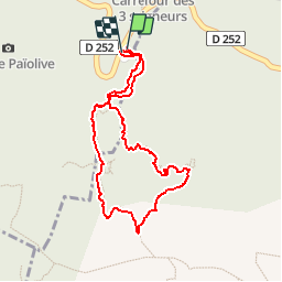

Length
2.1 km

Max alt
226 m

Uphill gradient
27 m
Km-Effort
2.4 km

Min alt
206 m

Downhill gradient
27 m
Boucle
Yes
Creation date :
2019-04-16 13:05:15.521
Updated on :
2019-04-16 16:00:52.633
2h21
Difficulty : Very easy

FREE GPS app for hiking
 SityTrail
IGN / Geographical institutes
SityTrail Plus
The world is yours!
About
Trail Walking of 2.1 km to be discovered at Auvergne-Rhône-Alpes, Ardèche, Les Vans. This trail is proposed by michelelfn.
Positioning
Country:
France
Region :
Auvergne-Rhône-Alpes
Department/Province :
Ardèche
Municipality :
Les Vans
Location:
Chassagnes
Start:(Dec)
Start:(UTM)
593815 ; 4916398 (31T) N.
Comments